As we all know, construction projects are large, complex jobs that need to be precise, timely, and safe. Over the years, 3D modelling has continued to improve to become an integral part of construction projects and to help with just that.
Correctly utilised 3D modelling has the potential to help improve cost management and projections, at all stages of the construction process - before, during and after.
Stage 1 - Before
In the past, it was quite difficult for people to get a true understanding of what the finished product might look like, you would have to wait until the project was finally taking shape or was built. But with the advances of 3D modelling, architects and engineers are able to create an accurate representation of the design and the surrounding area.
Creating a near-perfect representation of the final product, all team members are then able to review it, point out any flaws, discuss potential changes, meaning everyone can be on the same page, even before any excavation has begun.
By using 3D modelling, you're able to adequately calculate costs related to ground levelling, foundation pouring, and other preparation work. It’s easier to get very accurate measurements of the materials and labour that will be needed. 3D models can have materials and engineering solutions swapped out during planning, to improve upon costs without reducing safety or stability.
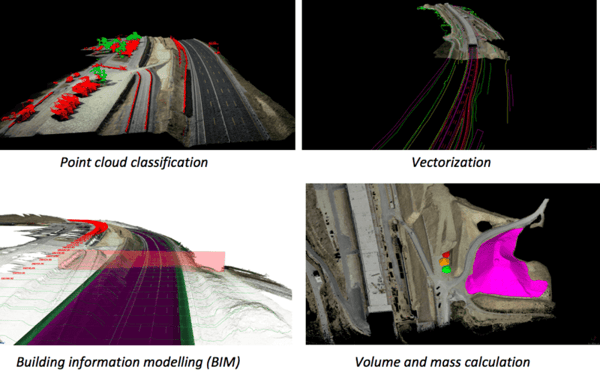
Take road building for example. The NZTA are able to create realistic 3D models for their Transmission Gully Project that accurately represent what the final product would look like. Our range of aerial mapping systems can help facilitate the creation of the these 3D models by quickly and easily mapping land that is less easily accessible.
“We’re covering miles while others cover feet...” Scott Dow - Aerotec LLC
Stage 2 - During
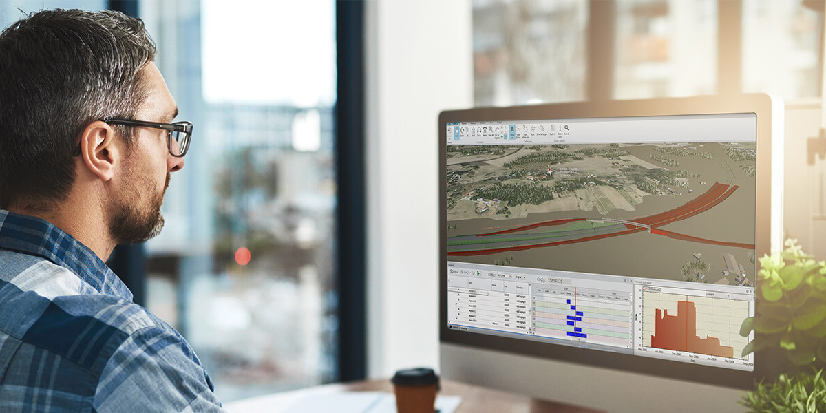
Whilst the project is underway, any 3D model can be quickly and accurately brought to life onsite. Powerful software collaboration tools like Topcon MAGNET project allow for transparency and communication at every stage and for every stakeholder in a project. These empower a user to (among other things,) review designs, resolve conflicts and coordinate changes from the office, boardroom, or straight from the construction site.
This is ideal for new construction projects, as well as for remodel and renovation projects. 3D imaging technology allows for the quick and easy layout of coordinated 3D models and document changes over accurate as-built data and images collected directly from the field, minimising communication issues and unnecessary duplication of efforts.
Even while a project is underway, you can continue to map the surrounding areas or upcoming highways to make sure your 3D models are true and accurate. Through tools like the Topcon RD-M1 Road Scanner, you can capture reality, at vehicle speeds. The IRD-M1 mobile mapping system offers high-density, high-precision, point clouds combined with high resolution panoramas with a system that is smaller, lighter and easier to handle. Simply put: map, extract, deliver.
Stage 3 - After
Even after the job is done, 3D models can still be archived and used at a later date. Knowing your information is stored in the cloud, and accessible from anywhere, is hugely advantageous for the company and client as it'll save any potential rework.
If a stretch of road or motorway needed to be upgraded and data was needed to be collected, tools like the Topcon RD-M1 Scanner can easily provide the solution. Simply attached to the back of your vehicle, the RD-M1 scanner collects a constant stream of data as you drive, delivering precise surface conditions. You can quickly scan miles of road in short time, without the need for costly lane closures or re-work.
Whether a project needs to be upgraded, modified, or extended, any addition can simply be added to the existing 3D model to simulate how they would impact the project overall.
To summarise, 3D modelling is already being used extensively throughout construction projects, and it’s easy to see why. Accurate 3D modelling makes it possible for architects and engineers to look ahead into time, seeing exactly how a project would be completed, and its impact on the surrounding area. With powerful solutions in mass data capturing, the door has been opened for entirely new workflows. Capture data once, quickly, then interrogate the data at your leisure, on your own at your desk or at the site. From original topo, to pre-construction inventories, to as-built documentation, the solutions that are now available deliver above and beyond results.
3D modelled projects that are backed by the technology can achieve better costing, better lead times, and better safety and stability. This strips back a lot of the struggles and hurdles that were originally faced in the construction industry, in turn, making everything more streamlined, and more simplified.
To find out how you can apply 3D modelling to accelerate your business, let's get started on creating a roadmap to determine your next steps. Click on the button below to get started!