Topcon’s MAGNET software is a suite of powerful and intuitive tools, with applications designed to increase your efficiency and productivity in the office and onsite. The software is easy to pick up for users at any skill level, and the comprehensive features will assist your team at every stage of the project.
Not only is the software more affordable than a lot of other applications, the connectivity between the Office software and the Field solution creates a seamless link between the team offsite and the crew out in the field. MAGNET also integrates with other applications like AutoCAD and Revit, with many file formats available to use.
In terms of compliance, Topcon and MAGNET have worked directly with Land Information NZ to prepare for the upcoming change in survey regulations that will require Field Notes to be submitted with a Cadastral dataset. These updates will make it easier for you to play by the new rules, leaving you more time to focus on your projects.
Keep reading to find out more about the MAGNET Field and Office features, and how you can take control of your project using this impressive suite of tools.
MAGNET Field
Ease-of-use
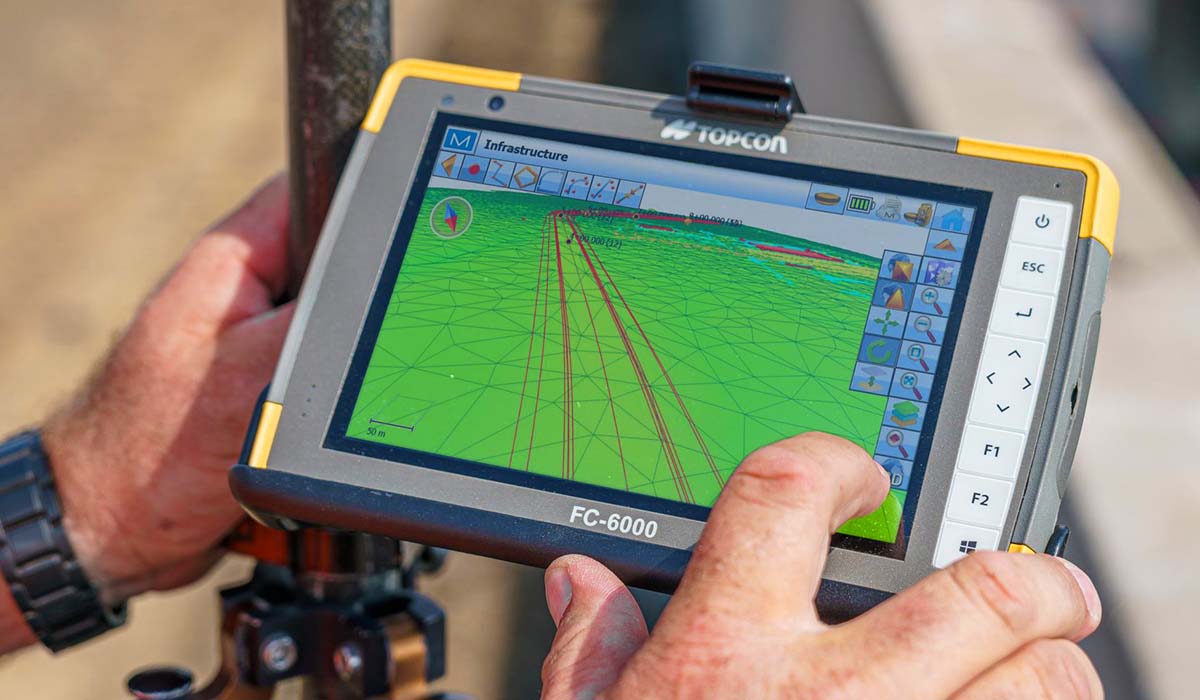
The MAGNET Field software is easy to use for contractors at all skill levels, and can be configured to meet the requirements of each user. Whether you’ve never used this kind of software before, or you’re an experienced surveyor with over 20 years of experience, the software provides the same basic set of tools – but goes more in depth depending on what you need.
The interface has large on-screen icons that intuitively guide you through a typical workflow, and has simple and advanced routines included. This saves time figuring out a logical process, and can be adjusted based on the level of complexity.
Comprehensive Features
MAGNET Field is a powerful tool that will allow you to complete a range of tasks more efficiently and accurately. Use the program to achieve volume measurements, layout tasks, road stakeout, fast as-built surveys, and connect to all Topcon robotic total stations and GNSS systems. You can then upload all of your field data to the secure Cloud storage within the software, making it easily available to everyone who needs it. The team in the office can also bring in full 3D models for the crew on site to see in real-time.
The far-reaching capabilities of the software will have a major impact on efficiency and productivity at every step of the process, plus – if you’re new to the equipment, MAGNET Field would be a good entry-point as data collection software.
Connected Technology
"Communication between the office and job site is imperative. Any updates and files, any data collected from the job site prospect can be dumped into the cloud making real-time communication extremely easy." — Mike Willis - Project Manager at Miller & Long Concrete Const.
The software makes building 3D models for machine control effortless by providing lots of tools to speed up and simplify entering the data to build the model. You can then easily export the model out for the crew in the field, who can quickly get the model out to your rovers and machines.
Another great feature is the ability to check and validate field data against Google maps while out in the field, which means you can quickly and effortlessly find old data points, as well as ensure that your data lines up, so you can move on with confidence.
MAGNET Office
Collaborate with the team
The connectivity between MAGNET Office and Field means that anyone in the team with a MAGNET account login can see what’s going on out in the field as it happens. People in the office can see what surveyors are picking up, and they can transfer that data using MAGNET Enterprise, to be viewed by anyone who needs it.
Something that sets MAGNET apart from other comparative software is the ability to transfer multiple file formats that aren’t usually supported by other applications. Additionally, MAGNET integrates with other software like AutoCAD and Revit, meaning that your CAD designer can upload their files seamlessly from different software.
Streamline material take-off
As part of the CAD package, the software is configurable to perform material takeoffs, and calculate volume costs during the bid cycle for accurate projections. This means you can carry out each project with a smart and efficient routine designed for professionals, saving time and money from the very beginning of the process.
Whether you’re load balancing the site, or determining trench depth and bedding materials, the Takeoff module tracks and calculates material types and volumes with accuracy. The software allows you to start projects with a material-driven estimate, and creates valuable cost and volume reports, which can then be quickly uploaded and distributed to anyone who needs the information to move on to the next part of the project.
Maximise Efficiency and Productivity
MAGNET Office helps to streamline the construction and survey layout workflow, inevitably saving you time and money at each and every stage of the project. Using the Office software alongside the Field solutions will take care of your data import-and-export needs, and provide valuable project insights for better site management and increased profitability.
Using MAGNET Office will optimise your digital workflows including your machine-control models, material takeoffs, final survey deliverables, and location-based project scheduling for mass-haul earthmoving projects. With its comprehensive suite of tools, MAGNET software is designed specifically to increase productivity on your next earth-moving, paving and surveying projects, so you can make the most of your resources.
If you’re interested in using any part of the MAGNET suite, get in touch to start a 30 day trial and test out the software on a no obligation license.